Field works. Example 14.
Complex engineering-geophysical survey for building
The survey area is situated in the Alagirskiy territory RSO-Alaniya on the northern slope of the Main Ridge of Big Caucasus. Engineering-geophysics survey in area year-round touring-recreational center “Mamison” included seismic survey and electric exploration.
Main targets of survey are:
- determination of the composition and thickness of friable quaternary and older sediments;
- define lithological structure of rock massif, tectonic dislocation and excessive fissuring and zones of fluid saturation;
-detect the depth of groundwater level and water confining stratum, hydrogeological characteristic of soil and aquifer.
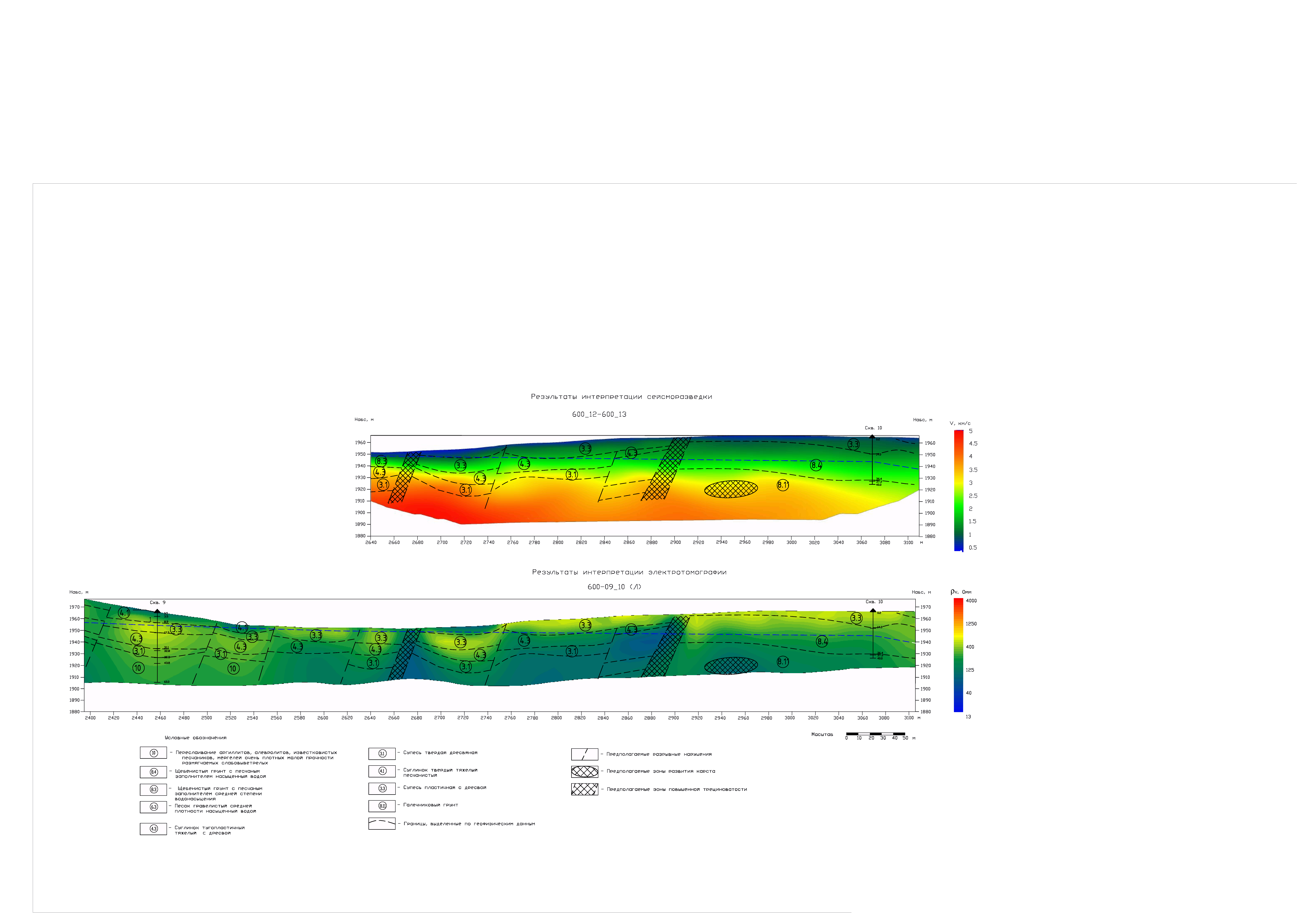
Borehole №10 is situated close to profile. Geological model obtain to a depth of 60 m. On model was observed (identified) complex of faults from point 2650 to point 2890. Along all length of a profile there is low-velocity layer, which has thickness 5 m and velocity 0.7-1.0 km/sec. For borehole data the layer to the depth 29 m is composed of crushed stone with loamy aggregate. Towards small number points thickness decreases to 10 m. Velocity is 1.3-2.0 km/sec. It is difficult to divide by seismic data interbeds of loam, sandy loam and boulder-gravel rock exposed by drilling because velocity variations are small. Layer has thickness about 25 m from point 3040 to point 3080. Thickness decreases towards small number points. Velocity in the range of 2.0 to 3.0 km/sec. Deeper, there is a heavy rock has velocity 4.5km/s.
The results of electrotomography survey were geoelectric model on the profile line 600-09_10 produced to a depth of 60m. Resistivity values are 70-7000 Ohm-m. Model is contains fault lines (points: 2400, 2490, 2540, 2610, 2650, 2730, and 2820). The upper layer from point 2400 to point 2540 to the depth 10 m has resistivity values 80-100 Ohm-m. According to borehole data at this depth the sandy loam interbed with clay. Deeper, crushed stone layer interbed with sandy loam. This layer has thickness 20 m and resistivity 300-550 Ohm-m. Layer in the base of the model includes interbedded members of argillite, siltstone and marl (resistivity is from 200 to 300 Ohm-m). In the central part of the model near-surface layer up to 12 m has resistivity values from 160 to 250 Ohm-m. In the base of the model from point 2580 to point 3000 there is a low-resistivity layer (70-160 Ohm-m) reveal that zone of jointing is on points 2870-2890. Probably, there is a karst at a depth of 35 m (points 2930-2970). In the right part of the model according to the borehole data the upper layer (thickness is 15-20 m) is composed of crushed stone and has resistivity values from 300 to 600 Ohm-m. Deeper, at this part of model, there is a layer of sandy loam, which has the resistivity values from 170 to 200 Ohm-m. The thickness of this layer is 10 m.
Results of seismic and electrical investigation allow to evaluate the physical parameters of the rock, to allocate the possible karst areas and to calculate engineering-geological characteristics and rock strength parameters. Seismic survey allows to obtain geological section to a depth of 30-60 m, allocate the possible karst areas and tectonic faults.
Seismic data were processed with the use of ZondST2D.
