Field works. Example 1.
Cross-borehole electrotomography for solving engineering problem
Nowadays cross-borehole electrotomography is one of the most high-resolution method to investigate borehole environment. It allows to select the comparatively inconsiderable irregularity deeply.
Surface survey resolution (i.e. ability to detail object) strongly decrease with depth. At the same time, during cross-borehole electrotomography the sensitivity smoothly decrease with distance from borehole. Therefore, cross-borehole electrotomography is the high-resolution method of electrical prospecting.
Logging procedure includes consecutive measurements of potential differences which depending on the position of the current sources across the borehole. This goes on in the following way: two cables put into two boreholes to image the environment between them. The special commutating equipment connects one of cable’s electrodes to transmitter, and then consistently scans pair of potential electrodes in the both boreholes. Further, the next current electrode is commuted and the process repeats. Thus, the “highlight” of geological model is performed from different views. The obtained results are improved.
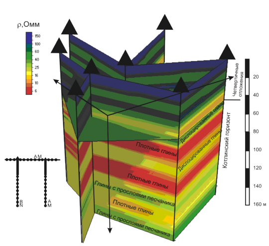
Cross-borehole electric tomography was carried on for clarification of geological structure. At each fixed position of one of pair of electrodes were measured for all positions of other pair of electrodes in the next borehole and on the surface. Then electrodes AM were shifted along borehole axis to 10 m and the process repeated. Distance between AM and BN is 10 m, distance between boreholes is from 20 to 40 m. Two-dimensional inversion result is the pseudo-volume resistivity distribution obtained with the use of ZondCHT. Layered structure of the earth (above 45 m) indicate as to quaternary deposits and bedrock presented by Kotlin horizon clay. The bedrock differ in resistivity: heavy clay come next to folded clay. In the base of the model clay resistivity has the higher values because of increased concentration of sandy fraction.
